Sunday, December 7, 2014

Zuma Ridge Hike


Zuma is a Chumash word meaning "abundance,"  and this hike affords you abundant views of the valleys, ravines and mountain ridges of the beautiful Santa Monica Mountains and the Pacific Ocean from a peak at 2400 feet above sea level.  It is a 5.9 mile hike one way, and a car drop off at Busch Drive trailhead, then driving up Kanan Road to Encinal Canyon where the trailhead starts.  It took about 3 hours to hike including a stop for a picnic on a boulder with a vast view of the ocean.  

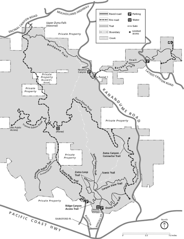
Zuma Ridge trail begins off of Encinal Road by a Fire Camp and is a reverse hike (meaning you are hiking the easier way by descending most of the time).  The hike begins with about a two-mile long 1100 foot ascent to the top of the ridge,where you pass the infamous Buzzards Roost estate, then descend about 4 miles and 2400 feet to the Busch Drive parking lot.  
This hike is much easier on a brisk winter day, as it is a sunny hike with very little shade for about 4 miles.  It can be uncomfortably hot in the summer.  

The trail begins at the Fire Camp dirt road.  You will see signs for Zuma Ridge trailhead when you head north from the parking lot.  It is a large fire road trail that you will be hiking, and an easy hike.  You will begin to ascend when you turn towards the ocean.  At the very top of the ridge, you will see a crop of pine trees, and the entrance to the Buzzards Roost estate.  It is the most remote and private residence in Malibu with 360 degree views for 100 miles on clear days.  Veer off to the right and remain on the trail, and you will see a stump and bench that overlooks one of the first and most dramatic views of the ocean.  There is a little trail to the right if you want to see it from a higher point of view.  


Most of the rest of the hike, you are descending to sea level.  
Stop along the way to see westward views of Boney Ridge, Sandstone Peak (the highest peak in the Santa Monica Mountains) and Trancas/Edison trail.  To the east, you can see radio towers that are off of Corral Canyon and the boulder outcropping by the radio tower by Saddle Peak off of Piuma Road (see my Corral Canyon and Saddle Peak hike blogs!).  When you get to a fork on the trail, veer right to stay on Zuma Ridge.  
It seems like you can see forever on a clear winter day.  It is an absolutely beautiful hike.  

For the car drop off at Busch Dr, take Pacific Coast Highway from Santa Monica, pass Pepperdine and about 7 more miles you will pass Kanan Dume Road.  A mile more and you will see Busch Drive next to a little commercial zone.  Turn right, and continue on Busch Drive to the end, where there will be a dirt parking lot.  Drop off a car here.  Then retrace back to Kanan Dume Road.  Turn left on Kanan, and about 6 miles turn left onto Mulholland Drive, then bear left on Encinal Canyon.  After 2-3 miles you will see L.A. County Fire Camp on the left.  Turn up the dirt road and the trailhead will be on the right.  


Monday, April 21, 2014

Santa Paula Canyon and the Punchbowl Hike

Tomas Aquinas College, Hoary Yerba Santa flowers, and
the creek along the trail.

Jeff and I wanted to do a wildflower motorcycle ride that was closer to us than Antelope Valley, so we decided to go the back route to Ojai through Santa Paula on the 150.  There was  a hike in the backcountry of Santa Paula that I remember hiking when the kids were little, and that just might have waterfalls and swimming holes too!! So off we went, leaving Torrance at 2 p.m. We were rewarded with the fragrances of spring and unexpected wildflower croppings, and a nice warm ride through back country.  We ran out of time and could not finish the 8 mile hike, but we did get to witness the pink moment (more on this later) and golden hour photos.  


 It was about a two hour drive with the usual Sunday traffic on the 405.  We took the 405 to the 101 North, and then exited on the Central Avenue exit in Camarillo.    Even this part of the ride was full of spectacular fragrances from orange blossoms to strawberries to Eucalyptus trees.  It was amazing!!

Thomas Aquinas College, founded in 1971, is a Roman Catholic school that only has one focus and one single integrated academic program - liberal arts.  It prides itself on the curriculum of the Great Books of the Western Tradition and has approximately 350 students.  Unmarried females and males must live on-campus in separate dorms.  There are no sororities or frat houses, and no alcohol on campus. Thirteen percent have cars.  Dang!  The closest pizza joint is at least 6 miles away!!   But I must admit, the campus is beautiful, with the backdrop of the green hills and yellow mustard.  

The first 1.3 miles is pavement that meanders through the campus, parking lots, and orchards. 


Then there are the oil rigs and caution signs that state "going off the trail could be harmful to your health."  The history of oil in this area dates back to 1861, when Josiah Stanford completed an 80-foot tunnel on the south flank of Sulphur Mountain.  Eventually 54 tunnels were dug using mostly Chinese Labor in the 1860's , making this method the most oil-producing in California.  The crude from the tunnels were delivered to Ventura in horse-drawn wagons and some of it was then shipped to San Francisco.  Another fun fact that my engineering boyfriend will enjoy is that Union Oil Company dug the Boarding House tunnel in 1890 using an old ancient method copied from ancient Egyptians that tunneled tombs in the Libyan mountains:  mirrors reflecting sunlight into the tunnel.  Thirty-two of the original fifty-four tunnels were still producing in 1997, and still experience dramatic production increases after earthquakes!    
TopaTopa Bluff in the background
Enjoy the results of the earthquake activity as you hike through this area.  Topatopa Bluffs is easily recognizable as bare, layered sediment and one of the highest points on the hike.  It is at an elevation of approximately 6000 feet above sea level, and is part of the Transverse Range system which is separated from the rest of the ranges by the San Andreas Fault.  In fact, the east-west axis of this mountain range is a result of a pronounced step in the fault.  Since the crust atop the Pacific Plate does not easily make the turn westward as it moves northwest, the pieces of crust are forced to compress and lift, giving us the beautiful mountains in this area.  This range includes the Santa Ynez Mountains, the San Gabriel and San Bernadino Mountains, the Santa Monica Mountains and the islands of San Miguel, Santa Rosa, Santa Cruz and Anacapa of the Channel Islands.  


Not only do you have the amazing history and geological formations to admire, but in the spring
Sticky Monkey Flower
there are lots of wildflowers.  We saw Indian Paintbrush, Sticky Monkey Flower, Litlle Venus' Looking Glass, Hoary Yerba Santa, and Coast Wall Flower.  Also there is plenty of shady spots in this hike, and you follow along a creek.  Its really beautiful!!

After the hike, follow highway 150 North to the town of Ojai.  See if you can catch the pink moment!!  It is when Topatopa Bluffs, due to the unique east-west face, captures the reflection of the sun as it sets.  Then try Deer Creek Lodge on the other side of Ojai, for dinner and drinks in a unique setting before heading home on Highway 33 on the other end of Ojai.  
This adventure will take the entire day!  You will need two hours both ways to complete the hike. 
Entrance to the hike is
to the right of the rock arch
To get to Tomas Aquinas College and the beginning of the hike, take the 101 West to Camarillo, and exit Central Avenue.  In 2.7 miles, turn right on N. Rose Avenue, then another 1.5 miles to CA 118W.  Turn left.  In 2.2 miles enter CA 126 East.  Then exit on CA 150 West/ S. 10th Street.  Follow this road out of town 5.8 miles to Tomas Aquinas College.  Park north of the gate in the dirt parking lot.  Walk over the bridge back to the gate and through the campus, following the "hikers" signs for 1.3 miles.  
When the pavement ends, follow the dirt trail past the fenced rigs.  When you reach the avocado groves, take the trail that follows the creek.  If you went up to the orchards, you are on the wrong trail!!  
We hiked about another 45 minutes on this trail.  We never made it back to the bouldered swim holes.  So this hike will have to be added on to later!!  Enjoy!!